THE MEASURABLE WORLD AROUND ME
Earth & Sky
From movement beneath our feet to clouds overhead and conditions beyond our atmosphere.
Your current area
Choose the area you want to explore.
RECORDED EARTHQUAKES · USGS
Seismic activity
Earthquakes recorded within 500 km of your selected area over the past 7 days, magnitude 1.0 and above.
Choose an area above to see nearby records.
What does this tell me?
Magnitude describes an earthquake’s size. Distance here is to its epicentre; it does not describe how strongly you felt it. Initial locations, depths and magnitudes can be revised, and the global catalogue may omit smaller local events. An empty list does not mean no seismic activity occurred.
This is a record of detected events, not an earthquake prediction or an emergency alert service. Follow local authorities for current safety instructions.
Source: USGS Earthquake Hazards Program · Earthquakes Canada for Canadian regional records.
OBSERVATIONS & MONITORING · NOAA SWPC
Space weather
A shared planetary overview. These readings do not measure conditions at your exact location.
Gathering space weather…
SHORT-RANGE AURORA FORECAST
Auroras · Northern & Southern Lights
The northern lights are aurora borealis; the southern lights are aurora australis. Explore both under one shared sky.
Visibility from my location
Choose your current area above to see local viewing conditions.
Open the Northern & Southern Lights forecast map
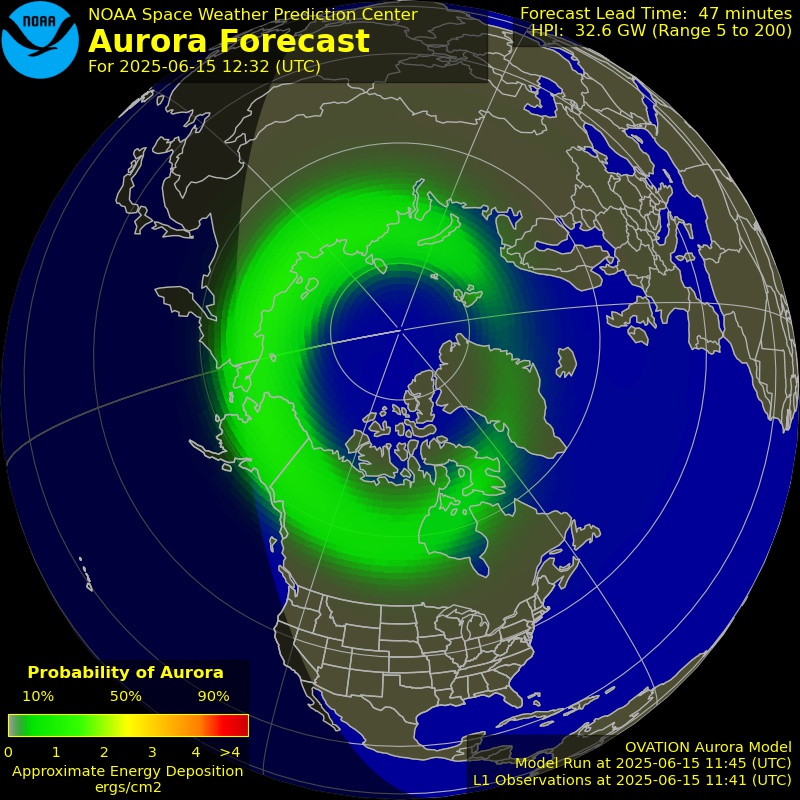
Official NOAA map; use its printed timestamp. The map refreshes independently of the local reading. NOAA’s forecast is short range, often around 30–90 minutes; the actual times above take priority.
Clouds, twilight, moonlight, nearby lighting and the horizon all affect what you can see. Moonlight, light pollution and terrain are not scored here. Viewing is never guaranteed. The decorative artwork is separate from the forecast.
What could be relevant near me?
Space weather can affect high-frequency radio, satellite navigation and power systems, depending on the event and region. A storm reading alone cannot explain a local Wi-Fi or mobile-data problem.
Aurora visibility also depends on geomagnetic location, darkness, cloud cover and local light. Kp alone is not a local viewing forecast. These readings do not predict a person’s mood or physical symptoms.
Source: NOAA Space Weather Prediction Center · Scale meanings · Official alerts, watches and warnings.
LOCAL CLOUD FORECAST · MET NORWAY
Clouds around me
Explore how much cloud is forecast, and which height layers it occupies around your selected city.
Choose an area above to see its cloud forecast.
These are model forecasts, not camera or weather-station observations. Layers can overlap, so their percentages do not add up to total coverage. A height layer does not identify an exact cloud type; unavailable values are left unavailable.
What kinds of clouds might I recognize?
- CirrusFine, featherlike streaks, usually high in the sky.
- CirrostratusA thin high veil, sometimes with a halo around the Sun or Moon.
- Altocumulus / altostratusMiddle-level patches or a broader grey layer.
- Stratus / stratocumulusLower sheets or broad, rounded cloud patches.
- CumulusDistinct puffs with relatively flat bases.
- CumulonimbusA deep, towering cloud that can develop an anvil-shaped top and thunderstorms.
This visual guide is general; the local forecast above does not confirm any of these types. Cloud heights vary with latitude and weather conditions.
Explore the WMO International Cloud Atlas →Forecast: MET Norway via Locationforecast · CC BY 4.0. Cosmic Identity selects and presents the forecast fields.
